In the cut-throat industry of maritime engineering, there is virtually no room to make mistakes. Whether installing a Ballast Water Treatment System (BWTS), a complex retrofit of an engine room, or the physical restoration of an offshore platform, the so-called close estimates are no longer an option. Marine 3D Laser Scanning and Modeling has emerged as the conclusive technology to record the as-built dimensions in millimeter accuracy.
Navy architects and marine engineers can develop a digital representation of any vessel by substituting the manual method of measuring with the use of high-speed laser data. This digital-first model guarantees that initial components are correctly aligned on the first attempt, eliminating fabrication mistakes, onsite clashing, and costly dry-dock time wastes.
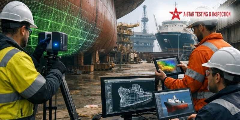
What Is Marine 3D Laser Scanning & Modeling?
Marine 3D laser scanning, in essence, is a non-contact, non-destructive technique that records the form of physical objects with a strip of laser light. The scanner has a rate of firing out millions of points in one second, and this distance between the sensor and the vessel surface is read out to create a Point Cloud.
This raw, dense data is then further modeled into ship CADs that are intelligent and workable using 3D modeling. This allows engineers to:
- model complicated engine room piping in 3D.
- Deformations of ship hulls are analyzed at the surface level.
- Create precise digital equivalents of assets to be managed in the long term.
Key Applications of Marine 3D Laser Scanning
The 3D scanning versatility is applied to the whole lifecycle of a marine tool, including the fabrication yard and final decommissioning.
1. Ship Retrofitting & Repair
Ship retrofitting and repair scanning is also the most widely used application currently. As new environmental laws demand Scrubber systems and BWTS to be installed, space in already available engine rooms is extremely expensive. Laser scan offers an ideal 3-dimensional map of the available space, and thus new piping can be developed around the pre-existing obstructions without any interference.
2. Hull & Structural Survey
The 3D scanning of ship hulls is necessary in order to know the structural problems that cannot be perceived by the naked eye. On comparing the scanned point cloud with the original design drawings, engineers would be able to identify:
- Hull plate buckling or indentation.
- Lateralization of the keel or rudder.
- General structural offshore platform jackets wear.
3. Digital Twin Creation
A ship digital twin is a simulation of a physical ship that is continuously connected to it. Operators are able to keep a good record of all changes by conducting regular scans. This helps in predictive maintenance, simulation of fuel efficiency, and virtual training of crew members.
4. Naval Architecture & Design
To naval designers, a precise 3D model of an old ship will be invaluable. It offers a basis of stability computations, weight distribution analysis, and design of significant structural changes, all in the process complying with ISO 3D laser scanning standards.
The Strategic Benefits: Why Go Digital?
Marine 3D Laser Scanning & Modeling Investment has a high Return on Investment (ROI) since time in dry-dock is maximized, as this is the most costly aspect of ship ownership.
- Eradication of Manual errors: Manual measurements can be subject to human factor errors and particularly in dark, cramped, or complex areas such as the bilge or the pump room.
- Less Vessel Idle Time: Scanning is fast. A specific region can be taken within hours, and the ship back to the sea; the engineering and the modeling can be done off-site.
- Attention to the First Fit: It is possible to do a fabrication off-site with complete assurance. Once the new parts arrive at the shipyard, they simply fit in, and there is no need to use costly on-site adjustments such as cut and shut.
- Quality Assurance with an engineering solution: Each scan is a permanent, auditable digital file that helps in marine engineering quality assurance practices.
The Process: From Field to Finish
- Site Survey and Planning: Determining scan locations so that there is 100 percent coverage and a line-of-sight of all essential parts.
- On-Site Laser Scanning: The use of high-resolution scanners (Leica or Faro) to scan millions of data points.
- Data Registration: Coalescence of several scans into one integrated, common coordinate system to create a complete point cloud.
- 3D Modeling (CAD Conversion): The transformation of the point cloud into smart 3D geometry (e.g., Revit, AVEVA, or AutoCAD).
- Clash Detection and Reporting: Conducting simulations to make sure that new designs do not interfere with the old ones.
Service Scope & Constraints
Critical Notice: Any Marine 3D Laser Scanning and Modeling work is carried out with strict attention to remain over the waters or a dry-dock setting. We do not offer subwater or undersea scanning. We target offshore assets and vessel structures that are available on the topside.
Standards and Compliance
Professional 3D scanning goes beyond pretty pictures; it is about data of engineering quality. Our services adhere to:
- ISO 3D Laser Scanning Standards: To manage data and metadata.
- Classification Society Requirements: Facilitation of documentation requirements of ABS, DNV, and Lloyd’s Register.
- Marine Engineering Procedures: Making sure that CAD products are all compatible to shipyard software.
Frequently asked questions: Marine 3D Laser Scanning and Modeling.
Q1: Is it possible to scan a vessel when it is on the sea?
Ans: Yes, in many cases. Although vibration may be a consideration, we can now scan numerous areas (such as the engine room or deck) during transit due to modern dynamic scanning technology and high-speed equipment, and save time in the process.
Q2: What is the average accuracy of a 3D scan?
Ans: To the majority of marine uses, we attain a precision of about 264 to 5mm and reach a high reliability of piping and structural fabrication.
Q3: Do you supply a point cloud or a final CAD model?
Ans: We provide both. The point cloud is frequently viewed by clients to make swift visual inspections, whereas the 3D model of the ships (CAD) is utilized to do formal engineering and production.
Q4: Does it involve underwater hull surveys?
Ans: No. Our marine laser scanning services are only applicable above-water and in dry-dock.
Conclusion: Driving Maritime Efficiency
Marine 3D Laser Scanning & Modeling is ceasing to be an extravagance; it is a part of modernity in maritime assets management. Turning the real vessels into the highly accurate digital models of the ships, shipowners and shipyards are able to mitigate risk, lower maintenance costs, and ensure that their fleet is capable of meeting the technical demands of tomorrow.
Since it is retrofitting environmental systems to offshore integrity, only a digital-first approach will guarantee 100% accuracy in a 3D world.
Call A-Star Testing & Inspection to start your professional Marine 3D Laser scan today and smooth out your next engineering project.